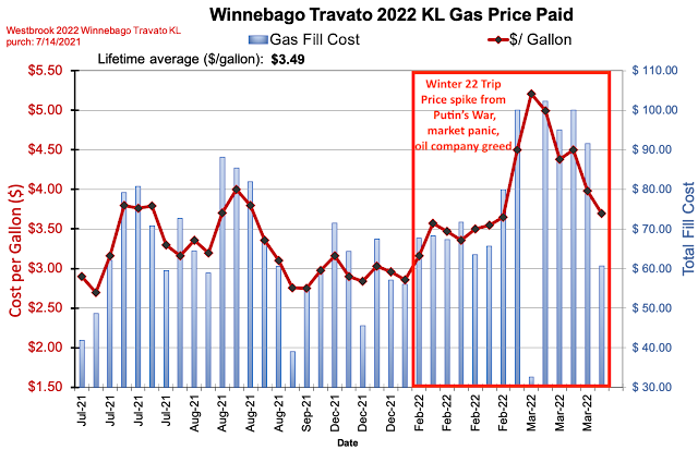
As we close out our 33-day winter adventure in the Bebopabago, it's time for some data.
Miles Driven: 4,711 miles
Average miles/day: 143
Average miles/day minus four days and 1,200 round trip miles in and out of Texas: 107
States outside of Texas: (4) NM, AZ, CA, NV
Time Driving: 105 hours
Avg Speed: 44 mph
MPG: 16.9 (vehicle calc); 16.0 (actual)
Gas Used: 284 gallons
Gas Cost: $1,093 ($33/day) - avg of $3.85/gallon
Highest temperature: 82ºF in Big Bend (Average high all trip of 68)
Lowest temperature: 18ºF in Fort Davis, TX (Average low all trip of 38)
Highest elevation driven: 8,700 feet (Cloudcroft, NM).
Times across the continental divide: 6
Lowest elevation: 282 feet BELOW sea level in Death Valley
Lowest temperature: 18ºF in Fort Davis, TX (Average low all trip of 38)
Highest elevation driven: 8,700 feet (Cloudcroft, NM).
Times across the continental divide: 6
Lowest elevation: 282 feet BELOW sea level in Death Valley
 |
| Trip Route |
Even with the gas price spike, our previous decades of efficiency have built up a big savings account for us, as outlined in my book The Joy of Efficiency (https://joyofefficiency.com)
Sleeping locations - cost avg ~$20/night
- State Parks (14)
- National Parks (7)
- Private Campgrounds (6)
- Boondocked in the forest - not in any parking lots (4)
- Moochdocked in driveways of relatives and friends (1)
Food
- Cooked most meals in the van.
- Stopped for groceries about 5 times.
- Ate out a few times.
- Avg cost per day = to what we would have spent at home.
- We ate very well, but increased activity (hiking) helped me shed a few pounds on the trip.
Glitches
- One awful Google Map routing near Portal, AZ put us on a narrowing dirt road, that became a bit sandy, and ended at a dead end fence. Brush was scraping both sides of the van toward the end. We had to back out quite a way to avoid getting stuck.
- Big Bend is always a highlight. We spent 4 days there and enjoyed some great hikes. East side blog; West side blog.
- I always love the unspoiled night sky at the McDonald Observatory in Fort Davis, TX. So many stars and the bright band of the Milky Way. Do Look Up blog link
- Cave Creek on the east side, and the Chiricahua National Monument on the west side were both new to me, and beautiful places. East side blog; West side blog
- The cactus tour of Saguaro National Park (both east and west) and Organ Pipe National Monument was enjoyable. cactus blog
- Joshua Tree National Park (blog) and Death Valley National Park (blog) were both fantastic.
- Between those two parks was one of my favorites - for a boondocking site and for an interesting arch. Near Lone Pine, CA we looked at the back side of the Sierra Mountains and visited Mobius Arch. blog link
- Finally, Valley of Fire State Park has some of the most intriguing colors of any place I've been. The multiple pastel shades of rock are not often seen in nature. blog link
Big Bend NP Chiricahua NM Cave Creek, AZ
 |
| Joshua Tree NP |
 |
| Joshua Tree NP |
 |
| Valley of Fire SP |
 |
| Valley of Fire SP |
 |
| Lone Pine, CA |
 |
| Superstition Mountains, AZ |
 |
| Zabriskie Point in Death Valley, CA |
- Paul


0 comments:
Post a Comment