Tuesday, March 15, 2022

Winter Trip Wrap Up - Data and Summary

As we close out our 33-day winter adventure in the Bebopabago, it's time for some data. 

Miles Driven: 4,711 miles
Average miles/day: 143
Average miles/day minus four days and 1,200 round trip miles in and out of Texas: 107
States outside of Texas: (4) NM, AZ, CA, NV
Time Driving: 105 hours
Avg Speed: 44 mph
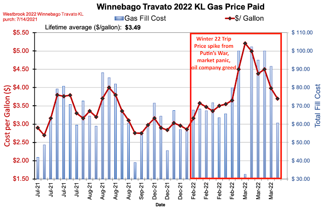
MPG: 16.9 (vehicle calc); 16.0 (actual)
Gas Used: 284 gallons
Gas Cost: $1,093 ($33/day) - avg of $3.85/gallon
Highest temperature: 82ºF in Big Bend (Average high all trip of 68)
Lowest temperature: 18ºF in Fort Davis, TX (Average low all trip of 38)

Highest elevation driven: 8,700 feet (Cloudcroft, NM).
Times across the continental divide: 6
Lowest elevation: 282 feet BELOW sea level in Death Valley
   
Trip Route


Even with the gas price spike, our previous decades of efficiency have built up a big savings account for us, as outlined in my book The Joy of Efficiency (https://joyofefficiency.com)


Sleeping locations - cost avg ~$20/night
  • State Parks (14)
  • National Parks (7)
  • Private Campgrounds (6)
  • Boondocked in the forest - not in any parking lots (4)
  • Moochdocked in driveways of relatives and friends (1)

Food

  • Cooked most meals in the van.
  • Stopped for groceries about 5 times.
  • Ate out a few times.
  • Avg cost per day = to what we would have spent at home.
  • We ate very well, but increased activity (hiking) helped me shed a few pounds on the trip.
Glitches
  • One awful Google Map routing near Portal, AZ put us on a narrowing dirt road, that became a bit sandy, and ended at a dead end fence. Brush was scraping both sides of the van toward the end. We had to back out quite a way to avoid getting stuck.
Highlights
  • Big Bend is always a highlight. We spent 4 days there and enjoyed some great hikes. East side blog; West side blog.  
  • I always love the unspoiled night sky at the McDonald Observatory in Fort Davis, TX. So many stars and the bright band of the Milky Way. Do Look Up blog link
  • Cave Creek on the east side, and the Chiricahua National Monument on the west side were both new to me, and beautiful places. East side blog; West side blog
  • The cactus tour of Saguaro National Park (both east and west) and Organ Pipe National Monument was enjoyable. cactus blog
  • Joshua Tree National Park (blog) and Death Valley National Park (blog) were both fantastic.  
  • Between those two parks was one of my favorites - for a boondocking site and for an interesting arch. Near Lone Pine, CA we looked at the back side of the Sierra Mountains and visited Mobius Arch. blog link
  • Finally, Valley of Fire State Park has some of the most intriguing colors of any place I've been. The multiple pastel shades of rock are not often seen in nature. blog link
    Big Bend NP
    Chiricahua NM
    Cave Creek, AZ


Saguaro NP

Organ Pipe NM

Joshua Tree NP

Joshua Tree NP
 
Valley of Fire SP

Valley of Fire SP

Lone Pine, CA

Superstition Mountains, AZ

Zabriskie Point in Death Valley, CA

- Paul
 

Sunday, March 13, 2022

New Mexico - Part II

We're making our way back home and spent the final couple of days in New Mexico. We visited Silver City, NM. The large strip mines to the SW and SE of Silver City are quite large scars on the land, but the town area is very nice. We even climbed the narrow road up to Pinos Alto at over 7,000 feet in elevation. There was snow scattered about on the ground, but it felt great out with bright sun, temperatures in the upper 40s, and light wind.

Up above Pinos Alto, NM

We stopped at the City of Rocks State Park and hiked among the massive rocks for a while. This one rock reminded me how inportant perspective is in how you see things. It's the same rock - one view looks like a thumbs up, or a #1 index finger, but move around about 90 degrees, and it looks like a rude gesture.
Thumbs up or rude rock - depends on your angle
City of Rocks State Park, NM

We boondocked for the night at a rest area that features a giant roadrunner sculpture made from trash. It was originally assembled by the artist and displayed at the landfill, but after a bit of history it ended up perched at this rest stop, where it's quite the popular photo stop. Read more about it here: https://www.roadsideamerica.com/story/14700.

Recycled material roadrunner

On day 31 of our trip (3/13) we stopped for another rare meal out on the recommendation of friend. We ate at La Posta in old Mesilla, NM. I think I had lost a little weight on the trip with all of our hiking, but I may have put it all back on at the restaurant. After stuffing ourselves, we hiked to Dripping Springs in the Organ Pipe Mountains. The spring was dripping or dribbling - a very tiny amount of water coming down.

Organ Pipe Mountains - Hike to Dripping Springs
We headed up the mountains into Cloudcroft, NM for a sunny, crisp afternoon. There was still plenty of snow at 8,700' elevation, and the parking lot was even closed for the hiking trail we planned to take. We stopped at the reconstructed rail trestle overlook. We then headed down the eastern side of the mountains to a free camping area in James Canyon near Mayhill, NM.

Restored trail trestle near Cloudcroft, NM

- Paul


Saturday, March 12, 2022

Prospecting for Rocks

We spent day 28 (3/10) of our trip at the Lost Dutchman State Park east of Phoenix, and on the western edge of the Superstition Mountains. It's named after a fabled lost gold mine (story link). We weren't searching for gold, like some modern day Yosemite Sam, but enjoying the weather and scenery. We had a nice 4-mile hike in 68ºF weather up to the volcanic tuff mountains, which were thrust up about 20 million years ago.

Lost Dutchman State Park
Bebop did a coyote impression and Elena did a pointing cactus impression. The sunset was the (literal) star of the day as we watched it drop behind a giant Saguaro cactus from our camper van window.
Bebop doing a coyote impression

Elena doing a pointing cactus impression

The quintessential desert sunset
The next day we drove across the mountains and stopped on the edge of the town of Superior. I had read about an old, closed obsidian mine that was accessible to the public. Another 4 mile round trip hike brought us to the mine. There are warning signs not to enter and a large fence with razor wire at the top, but someone had conveniently cut a big hole in the fence, so we strolled in for closer inspection.
The old mine

Obsidian, also called Apache Tears, are black volcanic glass. They were laying on the ground and cemented in the pearlite walls. We picked up some and chipped a few out of the walls. I noticed Elena's pockets bulging at one point. "Are those rocks in your pockets, or are you happy to see me:" I thought. It was rocks.

The bounty

We continued eastward at spent the night at Roper Lake State park near the base of Mount Graham, a 10,700' snow capped peak jutting up out of the desert.

- Paul


Wednesday, March 9, 2022

Bebop's Travel Tails - A Rest Day

Dad said today would be a slow day, or rest day. It seemed like a normal dog day to me. We left our overnight boondocking site and only drove about 80 miles. We had to buy some gas for the Bebopabago and dad seemed excited to find some for $4.39/gallon. He likes to point out that we have saved over $21,000 driving Prius cars since 2004, so a little extra gas money for the camper van gas is no big deal. He even made a chart.

We've saved a lot of gas and money by driving efficient cars for many years
We then took the Bebopabago to a car wash and I stayed inside while dad sprayed the high pressure water at me. I didn't get wet at all thanks to the windows. Then, for only the third time in 4 weeks, my hoomans ate at a restaurant for lunch instead of cooking in the van. I took a nap. 

We checked in at Havasu Lake State Park and our campsite backed up to the beach and water. We went for a long walk along the beach trail. Dogs weren't allowed on the beach (even though we are not as messy as many hoomans), so I went for a swim at the boat launch ramp. The water felt great.

View out the rear door - our bathroom with a view!

Our own private beach on Lake Havasu

I went for a dip and got a drink in Lake Havasu
While we were walking, something hurt my back paw. Dad thought it was a sticker from the grass, but I think a bug bit me. They couldn't find any sticker. I kept limping and stopping to lick my paw. I was scared and hurt, but my hoomans got me back to the van and rinsed it off. They even gave me a treat. Another nap cured it.

Dad went for a bike ride around the campground. Mom played in the water. I took a nap. Later, we walked over to a little hill, then a pretty cactus garden near sunset. I have met many cactus plants on this trip, and they are very standoffish. They do not seem to want you near them, so I have kept a safe distance - except when the rabbits dash into them, then I temporarily lose my concerns.

Sunset over Lake Havasu

See the Bebopabago?

- Bebop

Monday, March 7, 2022

Bebop's Hiking Tails - Valley of Fire

I finally got to hike on some trails again. We drove to Valley of Fire State Park in Nevada. On our way, we had to stop for gas in a small town. The gas station was called Area 51 Alien Travel Center & Brothel. We just filled up with gas and moved on. The vehicle line to get into the park was long. It was a nice Sunday and many local people came here. Luckily we found an available campsite, and it was scenic.

Our campsite at Valley of Fire State Park
We went out for a big hike on the Fire Wave, White Domes, and Seven Wonders Loop. That’s a lot of words, but it was 3.5 miles with about 500 feet of elevation gain. The rocks had many colors, including a lot of pastel colors I haven’t seen before. Of course, I’m a dog, so I don’t know much about colors, but my hoomans were talking about it.
Valley of Fire pastel colors

Valley of Fire hiking
There were several slot canyons and I liked running through those. Sometimes I had to look back to make sure my hoomans were keeping up. One time, at a really tall slot canyon, I asked dad if it was OK to enter. He looked happy when we came out the other end successfully.

Valley of Fire slot canyons
We saw something called the Fire Wave - it’s like a smaller version of The Wave that my dad hiked a few years ago.

Valley of Fire - Fire Wave
I met a few dogs and some nice people. One man really liked me and wanted to adopt me, but I like my current hoomans just fine. I heard him say he admired my stride as I walked away. There was one big dog who was posing for photos with her owner. When I went up to her to say hello, she growled and snapped at me. Those models can be a bit cranky during their photo shoots. I’m always happy - photos or not.

It was a very pretty first day of hiking and the temperature was a pleasant 60ºF. We’re here for another full day, too - more hiking tails to come.

- Bebop


Saturday, March 5, 2022

Valley of Death

On day 21 (3/3) we entered the Valley of Death, most commonly called Death Valley. We entered from the west and arrived at the Crowley Overlook adjacent to Rainbow Canyon. We were at 4,000 feet elevation and looked out to see some 11,000 foot mountains with snow on them - not the picture of Death Valley you have in your head. You could see the flat desert floor off in the distance, but the landscape was quite varied throughout the park. We dropped to about 2,000 feet and camped at Panamint Springs for the night. 
Rainbow Valley above Panamint Springs
We intentionally visited Death Valley in the cooler months. At Panamint Springs it was partly sunny and mid 80s. The relative humidity was 7%. The temperature cooled the next day for our full day in the valley - the high was about 77ºF. We climbed the 4,956 foot pass to then plunge down below sea level. Our first hike was Mosaic Canyon. We hiked about 1.5 of the 1.7 miles up, gaining about 750’. We ran into larger and larger boulder falls and decided to stop and return after the 5th climb. The canyon was very colorful.
Mosaic Canyon
Then we stopped at the Mesquite Sand Dunes and strolled out onto the sand. After that, we headed down to the Salt Creek Trail. Yes, there is water in the desert, and it was flowing from some springs. The pupfish live here and there were thousands of them swimming in the water as we walked along the creek. They can tolerate water that’s several times saltier than the oceans.
Mesquite Flats Sand Dunes

Salt Creek - home of the pupfish
We then drove down (literally) to Badwater, the lowest spot in North America at 282 feet below sea level. We walked out onto the salt flats and looked at the patterns left from the evaporation. There is water here too, from a spring running along a fault line. But you can’t drink the water because it’s very brackish - hence the name Badwater.
Badwater Basin - lowest point in North America (282 feet below sea level)
On our way back up to Furnace Creek we drove through Artists Drive and enjoyed the interesting colored hills and mountains.
Artists Loop Drive

Bebop is an artist
We also went to Zabriskie Point near sunset for some great views.
Zabriskie Point near sunset
Finally, we rolled into our campsite at Furnace Creek - just 190 feet below sea level. The song “Under the Sea” from Little Mermaid popped into my head. 

The winds were really strong overnight out of the south, and the low only got to around 61ºF. The van was rocking a bit - I’m glad I wasn’t in a tent. At our last phone/Wi-Fi connection a couple of days ago, they were forecasting a cold front and possible rain, but it hadn’t arrived yet. Bebop and I were out before dawn to see Venus lighting up the eastern sky and even a meteor streaking overhead. I heard some flying geese honking - they sounded a bit anguished at the lack of suitable water.

We walked back out at sunrise and suddenly the wind shifted and picked up. It was quite brisk, and we saw a couple of tents almost collapse, and items left outside were blowing and rolling. We dashed back to the camper - the cold front had arrived. It kept the temperature a pleasant 68ºF for a high. The rain tried, but was falling as virga - evaporating before reaching the ground.

Good weather - about half the record high of 134ºF
We hiked Golden Canyon in the morning, then drove to the Ubehebe Crater - a young volcanic crater. It blew just yesterday (well, in geologic time it seemed like yesterday - about 2,000 years ago).
Golden Canyon

Ubehebe Crater

Ubehebe Crater from higher up
While driving along a park road we spotted this cool piece of an old lava flow that looked like a throne. So we got out and played around for a bit.
The throne is lava!
We departed the park and headed over the pass to Beatty, NV for the night. When we arrived it was in the mid 40s and graupel fell from the sky for a few minutes. Then we heard Bebop growling and looked out to see a wild burro approaching our van. It saw our adjacent campers pull in with some groceries, and it was trying to grab some. They hurried into their trailer. Other campers came out and fed the burro - which just encourages their beggar behavior.
Graupel falls on Bebop, a wild burro visits for mooching

- Paul